GEOSPATIAL STRATEGIST | PIONEER OF CIVIC SPATIAL INTELLIGENCE™
Mapping Patterns, Revealing History, and
Delivering Strategic Clarity.
Bringing federal intelligence-grade spatial analysis, NASA Earth observation science, and community storytelling to civic advocacy and community accountability.
Introduction
About Me

Dionne Blanks is a New Orleans native, Tuskegee University HBCU alumna, and founder of Creole Mad Scientist LLC. She holds a Master of Science in Environmental Science with a concentration in Remote Sensing and brings over eight years of experience across federal intelligence, NASA Earth observation science, and environmental consulting.
An environmental scientist and remote sensing analyst by training, Dionne began her federal career as a NASA DEVELOP Project Lead. Applying satellite-derived Earth observation data to environmental and community health questions across the American South and internationally, collaborating with USDA, NOAA, and the U.S. Forest Service, and briefing findings at NASA Headquarters in Washington, DC. She went on to serve as a Geospatial and Imagery Analyst at the Department of Defense, where her analytical work reached the Presidential Daily Brief and she resolved a decades-long Intelligence Community analytical challenge. That federal foundation, NASA science rigor combined with intelligence-grade spatial methodology, is the backbone of everything she builds today.
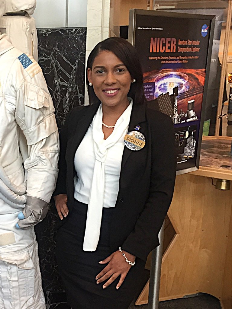
Dionne pioneered Civic Spatial Intelligence™ to bring that same methodology to the communities, causes, and fights that have never had access to this level of geospatial science. Her work spans geospatial boundary analysis, environmental justice mapping, Cancer Alley satellite documentation, community equity visualization, and civic accountability research. She has testified before the Louisiana Senate, produced a Louisiana legislative boundary analysis grounded in federal census methodology, built geospatial intelligence products for organizations and advocacy groups, and produced food access mapping for Washington DC's Wards 7 and 8 in partnership with community organizations working to end food inequity east of the Anacostia River. Her practice extends across the American South, the mid-Atlantic, and wherever the data points to a community that has been underserved, overlooked, or mapped over.
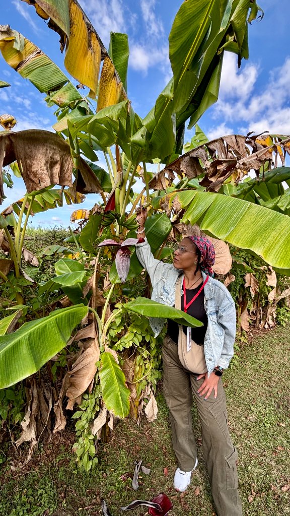
Whitney Plantation fieldwork
Creole Mad Scientist LLC is built on four pillars: civic geospatial strategy, environmental justice research and advocacy, city and community improvement through spatial science, and geospatial education for the next generation, particularly the youth of New Orleans, who deserve access to the same technology that has historically been reserved for federal agencies and well-resourced institutions. The maps already tell the truth. Creole Mad Scientist LLC exists to make sure the right people can read them.
Clearance Status
Former TS/SCI w/poly (inactive), clearance eligible for reactivation. Public Trust clearance eligible for FEMA and other federal agencies.
The most powerful thing a map can do is tell the truth.
Capabilities
Technical Arsenal
A comprehensive toolkit spanning remote sensing, geospatial analysis, development, federal operations, civic strategy and political intelligence.
Remote Sensing & Imagery
- Satellite Imagery Processing
- Aerial Imagery Management
- Landsat & Multi-Spectral Analysis
- LiDAR Processing
- Change Detection
- Satellite Imagery Intelligence Analysis
- Sensor Metrics
GIS & Geospatial Analysis
- QGIS & ArcGIS Pro / ArcGIS Online
- Complex Spatial Analysis & Change Detection
- Geodatabase Design & Enterprise Data Management
- Cartography, StoryMaps & Web Mapping Applications
- Environmental Justice & District Demographic Mapping
- Pattern Recognition & Pattern of Life Analysis
- Statistical, Predictive & Land Surface Temperature Analysis
- Google Earth Engine & NDVI Vegetation Health Analysis
Civic Geointelligence & Political Strategy
- Voter Concentration Mapping
- District Demographic Analysis
- Redistricting & VRA Compliance Analysis
- Political Narrative Development
- Environmental Justice Mapping
- Legislative Testimony & Policy Advocacy
- Community Equity Visualization
Federal & Environmental
- Environmental Assessment (EA/EIS)
- NEPA Compliance
- Wetland Delineations
- DoD Planning Framework
- Executive Orders 11988/11990
- Intelligence Analysis
- Multi-Agency Coordination
Technical Development
- Arcade Expressions
- Python Scripting
- ArcPy
- Google Earth Engine
- Web App Development
- Dashboards and StoryMaps
- Survey123 and Field Maps
Career Journey
Professional Experience
From federal intelligence to civic innovation — a career built on precision, spatial thinking, and impact
Geospatial & Environmental Analyst
Creole Mad Scientist, LLC
- Applying federal-grade remote sensing and geospatial science to civic accountability, environmental justice, and community equity research across the American South and Northeast. Translating NASA Earth observation data, federal regulatory databases, Census demographics, and public infrastructure records into spatial intelligence products for legislative bodies, advocacy organizations, nonprofits, and community stakeholders.
- Founded and operate an independent geospatial science practice producing publication-quality thematic and reference map products integrating Landsat Collection 2, Sentinel-2 MSI, NASA PACE OCI, NASA FIRMS thermal anomaly data, FEMA NFHL, NOAA coastal data, EPA TRI, and U.S. Census Bureau demographic data across concurrent environmental justice and community accountability research projects.
- Produced the Louisiana Can't Hide Series and Mapping the Machine: a combined thirteen-map geospatial accountability series documenting industrial burden, data center infrastructure, nuclear waste proposals, agricultural watershed impacts, coastal wetland loss, and water quality conditions across Louisiana.
- Conducted active OSINT investigations integrating public property records, corporate entity filings, Secretary of State databases, deed archives, and satellite imagery exploitation to document coordinated land acquisition patterns and environmental accountability gaps in majority-Black communities.
- Developed food access geospatial documentation for Washington DC's Wards 7 and 8 in partnership with Dreaming Out Loud Inc., including a Food Access Gap Map and Transit and Vehicle Access Analysis supporting a $10 million community capital campaign and DC Council advocacy.
- Produced publication-quality thematic and reference maps, interactive ArcGIS dashboards, StoryMaps, and data visualizations translating complex spatial findings for legislative bodies, advocacy organizations, nonprofits, and community stakeholders.
Geospatial Storyteller & Environmental Cultural Interpreter
Independent Research
- Design and lead community-facing geospatial programs connecting Black Southern communities to their cultural landscapes, environmental heritage, and civic history through spatial data and storytelling.
- Develop public-facing data visualization products, interactive maps, and digital content translating complex spatial analysis into accessible community narratives.
- Build relationships with community organizations, elected officials, and advocacy partners to amplify civic engagement and community impact through place-based storytelling.
Geographic Information Systems Analyst
Stantec Engineering Services Company
- Designed and deployed enterprise GIS applications, interactive dashboards, and data visualization tools for federal infrastructure projects; developed Python automation tools reducing processing time by 50%.
- Conducted environmental impact assessments and spatial analysis supporting federal regulatory compliance; collaborated with cross-functional technical and agency stakeholder teams.
- Produced technical reports and presentations communicating complex spatial findings to technical and non-technical audiences including federal agency leadership.
Geospatial and Imagery Analyst
Department of Defense
- Applied federal intelligence-grade geospatial analysis and spatial intelligence methodology — the same analytical framework now applied to political and civic strategy — to produce decision-support products for the highest levels of the U.S. government, including two products presented at the Presidential Daily Brief.
- Resolved a three-decade Intelligence Community analytical challenge by developing the IC's first documented pattern of life analysis for a complex adversarial network — demonstrating visionary, first-of-kind analytical thinking directly applicable to pioneering new applications of geospatial science.
- Developed Python automation tools cutting production timelines 30%; administered Oracle and SQL Server enterprise geodatabases; mentored three analysts; served on the Data Governance Council for two agency offices.
Project Lead & Research Analyst
NASA DEVELOP
- Led interdisciplinary federal research team applying NASA Earth observation data to analyze environmental conditions and community health across diverse geographic environments; briefed findings at NASA Headquarters, Washington, D.C.
- Collaborated with USDA, U.S. Forest Service, NOAA, and the U.S. Embassy of Costa Rica; delivered policy-relevant findings to federal and international government stakeholders.
Portfolio
Research Projects & Deliverables
Highlights from intelligence operations, environmental research, and geospatial innovation
June 2026
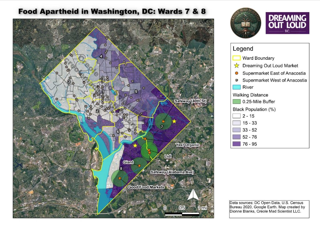
Mapping Food Apartheid in Washington, DC — Wards 7 & 8
Washington DC has 46 full-service grocery stores serving six wards on the west side of the Anacostia River. Wards 7 and 8 — the two most majority-Black wards in the city — share six. That is not a food desert. That is a policy. And it is visible on a map.
Map 1 — Food Access Gap Census tract shading shows the percentage of Black residents by neighborhood. The darkest purple areas — concentrated entirely in Wards 7 and 8 — also have the fewest grocery store locations. The contrast between east and west of the Anacostia River makes the disparity undeniable.
Map 2 — Transit & Vehicle Access The same geography, now showing the percentage of households without a vehicle. Darker red indicates higher transit dependency. Metro lines barely reach the areas where the few grocery stores exist — leaving car-free residents dependent on long bus rides or walking to carry groceries home.
November 2025
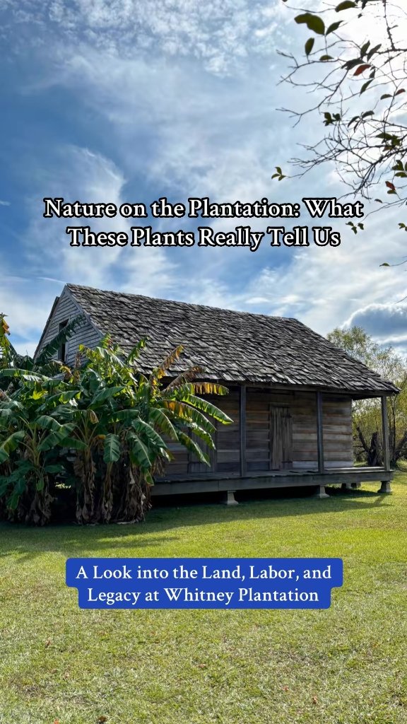
Nature on the Plantation
In Nature on the Plantation, I conducted on-site field identification of trees and plants at Whitney Plantation, explaining how each species connected to the daily lives of the enslaved—whether as tools for autonomy, sources of exploitation like indigo and sugarcane, or plants tied to ancestral practices. This work blends ecological observation with cultural and historical interpretation, demonstrating how field-based analysis can reveal deeper narratives embedded in the landscape.
2017 – 2018
NASA Earth Observation Research
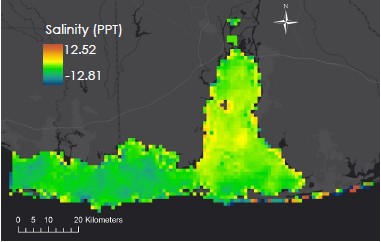
Led interdisciplinary research project analyzing long-term water quality trends in Mobile Bay and the Mississippi Sound using MODIS ocean color, SST products, and Landsat 5 turbidity data. The resulting qualitative assessment supports fisheries management and enhances habitat restoration efforts for key species such as the Eastern oyster.
Academic Foundation
Education
Master of Science in Environmental Science
Tuskegee University
Tuskegee, AL
Thesis
"Assessing Changes in Forest Health Using Remote Sensing in Alabama"
Applied advanced remote sensing techniques including long-range temporal analysis, multi-source satellite data integration, change detection methodologies, and geospatial database development for strategic resource management. Research directly applicable to planning and environmental monitoring.
Bachelor of Science in Environmental Science
Tuskegee University
Tuskegee, AL
Foundation in environmental science principles, geospatial analysis, and field research methodologies.
Professional Development
Certifications & Training
Federal & Intelligence
- Essentials of Critical Thinking and Structured Analytic Techniques
- Fundamentals of NGA Intelligence Writing
- HUMINT Control System (HCS) Enclave Processing Mode
- Cyber Awareness Challenge - IC Version
- NGA Business Continuity/Disaster Recovery Orientation
GIS & Remote Sensing
- ERDAS Imagine
- Intermediate Geographic Information Systems for Analysis
- Spatial Statistics
- Sensor Mechanics (2021)
- Radar (SAR) Image Analysis
- Change Detection Techniques
- Image Classification & Feature Extraction
Environmental
- Environmental Impact Assessment (EIA)
- Wetland Delineation Methodologies
- Soil Characterization & Mapping
- FEMA Floodplain Analysis
- Habitat Suitability Assessment
- Vegetation Identification & Classification
- Land Cover & Land Use Interpretation
Recognition
Awards & Recognition
Louisiana Senate Floor Testimony
May 2026Congressional Redistricting, Prison Gerrymandering, Cancer Alley Environmental Injustice & Voter Suppression in CD2
Testified before the Louisiana State Senate on critical issues affecting Congressional District 2, including redistricting implications, prison gerrymandering practices, environmental justice in Cancer Alley, and voter suppression.
1st Place, Graduate Student Competitive Poster Presentation
2017Association of Research Directors (ARD), Inc., 1890 Land-Grant HBCU Research Conference
Awarded first place among graduate student competitors for research poster presentation.
Certificate of Membership — Honor Society of Agriculture
2017Tuskegee University Chapter
Recognized for high scholarship, outstanding achievement, and service.
Research Presentation — NASA Headquarters
Summer 2017Washington, D.C.
Presented Cocos Island and Southeastern U.S. forest health research findings as Project Lead.
Presidential Daily Brief Contributor
2019–2022National Geospatial Intelligence Agency
Contributed two formal intelligence products to the Presidential Daily Brief.
Executive Leadership Shadowing — NGA Director of Analysis
October 2019National Geospatial Intelligence Agency
Participated in an executive leadership shadowing opportunity with NGA's former Director of Analysis, Susan Kalweit, gaining direct exposure to senior intelligence leadership and agency-wide analytical strategy.
NGA Time Off Award
FY19 Q4National Geospatial Intelligence Agency
Recognition for exceptional contributions to mission requirements.
Tuskegee National Alumni Association — New Orleans Chapter
HistorianServing as chapter historian, preserving and documenting the legacy of Tuskegee alumni in the New Orleans community.
Data Governance Council Member
Office of Eurasia and Africa & Office of Asia-Pacific (NGA)
Selected to serve on the Data Governance Council, contributing to data standards and best practices across regional intelligence offices.
Get In Touch
Let's Connect
Whether you are a campaign, an elected official, an advocacy organization, a federal agency, or a community that needs its story told through data — Creole Mad Scientist LLC is ready to work.
Creole Mad Scientist LLC offers paid strategic consultations for campaigns, organizations, journalists, researchers, and community advocates. Book your session below.
Please note: Creole Mad Scientist LLC consultation sessions do not include map production, data analysis, or methodology disclosure. All strategic recommendations are provided verbally during the session and summarized in writing. Commissioned map products are priced separately. Contact creole.madscientist@gmail.com for commission inquiries.
Book Consultation© 2026 Creole Mad Scientist LLC. All rights reserved.